Flow Program projects
The Flow Program is advancing essential water and wastewater projects over the next decade. It will strengthen the systems that provide our growing communities with high-quality tap water and wastewater services.
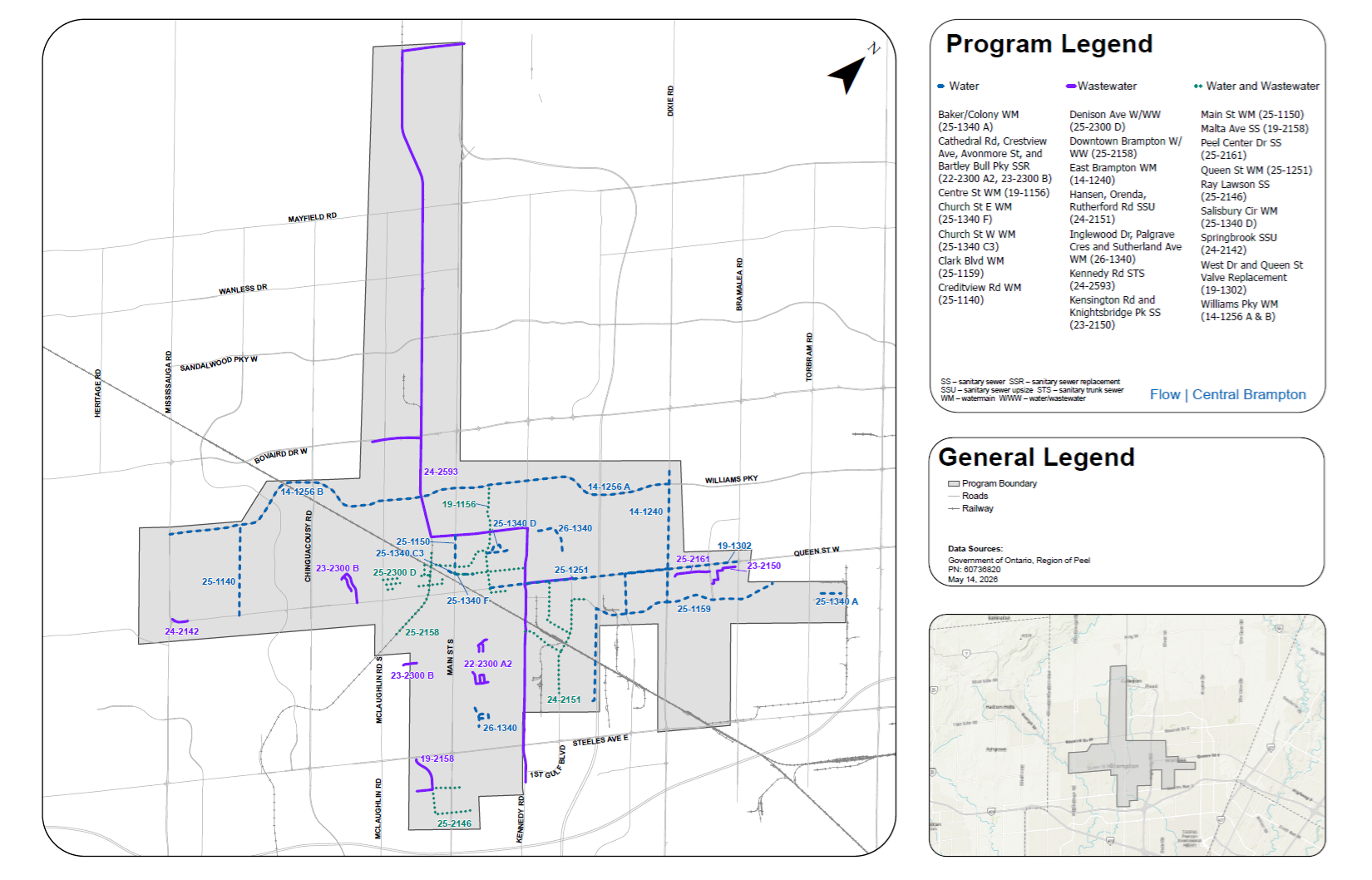
The Flow Program is advancing 30+ essential water and wastewater projects across the city over the next decade, covering an approximate geographical area from Ray Lawson Boulevard in the south, Old School Road in the north, Mississauga Road in the west and east of Torbram Road in the east.
Current Flow projects
- Baker Road and Colony Court watermain replacement (Project 25-1340 A)
- Cathedral Road, Crestview Avenue, Avonmore Street and Bartley Bull sanitary sewer replacement Project 22-2300 A2 and Project 23-2300 B
- Centre Street watermain installation (Project 19-1156)
- Church Street East watermain replacement and improvement (Project 25-1340 F)
- Church Street West watermain replacement (Project 25-1340 C3)
- Clark Boulevard watermain installation and replacement (Project 25-1159)
- Clark Boulevard from Rutherford Road to Hansen Road South watermain installation (Project 20-1157)
- Creditview Road watermain (Project 25-1140)
- Denison Avenue and West Street sewer replacement and watermain extension (Project 25-2300 D)
- Downtown Brampton water and wastewater capacity improvements (Project 25-2158)
- East Brampton watermains (Project 14-1240)
- Hansen, Orenda and Rutherford Road sanitary sewer replacement (Project 24-2151)
- Inglewood Drive Palgrave Crescent and Sutherland Avenue watermain replacements (Projects 26-1340)
- Kennedy Road sanitary trunk sewer (Project 24-2593)
- Kensington Road and Knightsbridge Park sanitary sewer replacement (Project 23-2150)
- Malta Avenue sanitary sewer installation (Project 19-2158)
- Main Street watermain installation (Project 25-1156)
- Murray Street sanitary sewer replacement (Project 26-2300 B)
- Peel Centre Drive sanitary sewer replacement (Project 25-2161)
- Queen Street watermain and sanitary sewer (Project 25-1251)
- Ray Lawson Road and Sir Lou Drive sanitary sewer and watermain replacement (Project 25-2146)
- Salisbury Circle watermain replacement (Project 25-1340 D)
- Springbrook sanitary sewer replacement (Project 24-2142)
- Upper East Brampton sanitary trunk sewer (Project 25-2256)
- West Drive and Queen Street valve replacement (Project 19-1302)
- Williams Parkway watermain (Project 14-1256)
Planned Flow projects
Upper East sanitary trunk sewer (Project 26-2596)
Schedule B Municipal Class Environmental Assessment and preliminary design for the Upper East sanitary trunk sewer along Airport Road in the City of Brampton and Town of Caledon. This project includes the construction of a new sanitary trunk sewer along the Airport Road corridor from north of Highway 413 to its connection point at Castlemore Road and Bovaird Drive.
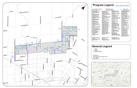
Flow will deliver many water and wastewater capital projects in Caledon, covering an approximate geographical area from Sandalwood Parkway and Countryside Drive in the south, Castlederg Side Road in the north, Mississauga Road in the west, and Mount Hope Road to the east.
Current Flow projects
- Centreville Creek Road watermain (Project 25-1163)
- Clarkway Drive, Humber Station Road and Healey Road watermains and sanitary sewer (Project 23-2272)
- Humber Station Road sanitary trunk sewer (Project 24-2194)
- Macville Booster Pump Station at King Street and Coleraine Drive (Project 24-1969)
- The Gore Road sanitary selwer and watermain (Project 24-2274)
- Victoria C3 watermain installation (Project 10-1210 C3)
- Victoria C5 watermain and sanitary sewer installation (Project 10-1210 C5)
Planned Flow projects
Airport Road watermain (Tullamore) (Project 24-1183)
Construction of a new watermain along Airport Road from Mayfield Road north 1,300 metres to a future street, to support planned growth and future development in the Tullamore Industrial Area.
Bramalea Road watermain (Project 31-1199)
Construction of a watermain along Bramalea Road, extending from a future street south to an existing watermain connection stub located 500 metres north of Mayfield Road. This installation will support the extension of the local water distribution network and accommodate future growth.
Castlederg elevated tank (Project 26-1584)
Construction of an elevated tank in the vicinity of Emil Kolb Parkway and Highway 50 area to support future growth and enhance water system reliability. This new tank will provide additional storage capacity and provide consistent and dependable service to the area.
Centreville Creek Road sanitary sewer (Project 31-2199)
This project involves the construction of a sanitary sewer on Centreville Creek Road extending from Mayfield Road to 200 metres south of Healey Road to support planned growth.
Chinguacousy Road watermain and sanitary sewer (Project 24-1182)
Installation of a new watermain along Chinguacousy Road from Old School Road to Tim Manley Avenue. A new sanitary sewer will also be constructed along Chinguacousy Road from Tim Manley Avenue to approximately 1.1 kilometers north. Both projects will support service to planned developments in the area.
Creditview Road watermain (Project 24-1188)
Installation of a watermain along Creditview Road extending 1.6 kilometers north from Mayfield Road. This watermain will support future development in the Alloa area.
Goreway Drive sanitary sewer (Project 24-2166)
Construction of a new sanitary trunk sewer along Goreway Drive from Countryside Drive to Mayfield Road. This new infrastructure will accommodate population growth and ensure a reliable wastewater service by expanding sewer capacity along Goreway Drive.
Healey Road sub-transmission main, watermain and sanitary sewer (Project 24-1192) (Phase 1 and 2)
Construction of Phase 1 section of watermains extending 800 metres west from Humber Station Road that will connect to future Phase 2 watermains on Healey Road extending east from The Gore Road, helping to supply the Bolton elevated tanks and improve overall system capacity and reliability. Construction of a new sanitary sewer will be installed along Healey Road, extending 800 metres west from Humber Station Road to service a new development.
Heart Lake Road sanitary sewer (Mayfield West Phase 3) (Project 24-2187)
Construction of a new sanitary sewer along Heart Lake Road, extending north from Speirs Giffen Avenue. The new sanitary sewer, will connect to future infrastructure on Speirs Giffen Avenue and Abbotside Way, providing essential servicing to support future development in Mayfield West.
Highway 50, Emil Kolb Parkway, Columbia Way watermain, sanitary sewer and forcemains (Projects 24-1191, 24-2192, 24-2195, 24-2196, and 24-2197)
Construction of a new watermain along Highway 50, Emil Kolb Parkway and Columbia Way. Additional sanitary sewer infrastructure will provide service from Columbia Way to Emil Kolb Parkway and extend along Emil Kolb Parkway, from Highway 50 to the future Humber Sewage Pump Station, increasing system capacity.
To further improve the reliability and performance of the wastewater network, twin sanitary forcemains will also be constructed along Emil Kolb Parkway, from the Humber Sewage Pump Station to King Street. Together, these upgrades will enhance wastewater conveyance capacity, reduce the risk of sewer overflows, and ensure safe, efficient wastewater management for the growing community.
Humber sewage pumping station (Project 24-2984)
Construction of a new Sewage Pumping Station located in the vicinity of the Humber River on Emil Kolb Parkway, west of Highway 50. This project will help accommodate future growth in the area, reduce the risk of sewer overflows, and ensure safe and efficient wastewater management for the community.
Humber Station Road watermain (Project 24-1194)
Construction of a watermain along Humber Station Road, from Healey Road north for 1,200 metres to a future street, and east from Humber Station Road to the existing West Bolton Elevated Tank. This new watermain will support proposed developments in the area and enhance capacity within the local water system.
Humber Station Road watermain (Project 27-1191)
Construction of a watermain along Humber Station Road, from the future street 1,200 metres north of Healey Road then north to 500m south of King Street. This new watermain will support proposed developments in the area and enhance capacity within the local water system.
Humber Station Road watermain (Projects 24-1194 and 29-1199)
Construction of a watermain along Humber Station Road extending from Healey Road to King Street then along King Street to The Gore Road. This new infrastructure will accommodate population growth and provide essential servicing to support future development along Humber Station Road.
Hurontario Street watermain (Project 27-1188)
Construction of a watermain along Hurontario Street, from Dougall Avenue to Old School Road to support planned development.
Innis Lake Road watermain (Project 24-1197)
Construction of two new watermains along Innis Lake Road, extending from the Tullamore Pumping Station (near Mayfield Road) to Healey Road. The watermains will boost supply to the Bolton elevated storage tanks and improve overall system capacity and reliability while also supporting future population growth. A new sanitary sewer will also be installed along Innis Lake Road, from a newly constructed sewer located north of Mayfield Road to Healey Road to accommodate future development in the area.
Kennedy Road trunk sewer (Project 24-2593)
Construction of a sanitary sewer trunk along Kennedy Road from Queen Street East to Vodden Street East, Vodden Street East from Kennedy Road to the former Orangeville-Brampton Railway Corridor, the former Orangeville-Brampton Railway Corridor from Vodden Street East to Bovaird Drive West, Bovaird Drive West from the former OBR to Hurontario Street, Old School Road from Bovaird Drive West to Hurontario Street, and Hurontario Street from Old School Road to Queen Street East to improve sewage conveyance capacity and support planned growth in the surrounding area.
King Street, Emil Kolb Parkway watermain and sanitary sewer (Project 24-1190)
Construction of a new sanitary sewer and watermain along King Street extending 675 metres west of Humber Station Road to Emil Kolb Parkway. The watermain continues south along Emil Kolb Parkway to King Street West to the future Macville Booster Pump Station, (Project 24-1969). The project will support planned growth and future development within North Bolton by expanding municipal water and wastewater servicing infrastructure.
King Street watermain (Project 31-1199)
Construction of a watermain along King Street from The Gore Road to Humber Station Road. This new watermain will support proposed developments in the area and enhance capacity within the local water system.
Macville transmission main and elevated tank (Project 28-1583)
A new transmission main and elevated tank are being constructed off of The Gore Road approximately 2.4 kilometers north of King Street to support future development and improved system service to the area. The new tank and transmission main will provide additional capacity and improve system resilience.
McLaughlin Road forcemains (Project 24-2185)
Installation of twin forcemains extending approximately 240 metres south from the future McLaughlin Sewage Pumping Station, crossing Etobicoke Creek. These forcemains will provide wastewater servicing to support future development in Mayfield West.
McLaughlin Road sanitary sewer (Projects 25-2189 and 24-2188)
Construction of a new sanitary sewer along McLaughlin Road extending 800 metres north from the future McLaughlin Road Sewage Pumping Station. A sanitary sewer will also be constructed along McLaughlin Road extending 350 metres north of Tim Manley Avenue and continuing north for an additional 420 metres.
McLaughlin Road sewage pumping station (Project 24-2985)
Construction of a new sewage pumping station located on McLaughlin Road, near Etobicoke Creek. This project will support the expanded sewer capacity being constructed in the area for future growth.
McLaughlin Road watermain (Project 24-1187)
The McLaughlin Road Watermain Project will construct a new watermain along McLaughlin Road, from Old School Road to the south side of Etobicoke Creek. This new watermain will help to support the planned growth of Mayfield West by improving access to the water supply. This project is part of ongoing efforts to build strong, sustainable infrastructure within the Region of Peel for the future.
McVean Drive sanitary sewer (Project 29-2169)
This project involves the construction of a sanitary sewer along McVean Road, extending from Mayfield Road to Countryside Drive to support planned growth and future wastewater servicing in the area.
Mississauga Road / Old School Road watermain (Project 24-1180)
Construction of a new watermain along Mississauga Road and Old School Road, extending from the future West Caledon Elevated Tank (in the vicinity of Old School Road and Mississauga Road) to Chinguacousy Road to accommodate future growth and improve system efficiency.
Mississauga Road sanitary sewer and road resurfacing (Project 27-2144)
Construction of a sanitary sewer along Mississauga Road extending from Mayfield Road north to support development in this area. This section of Mississauga Road from Mayfield Road to Old School Road will be resurfaced after construction of the sanitary sewer and watermains on Mississauga Road is completed.
Mississauga Road trunk sanitary sewer (Project 25-2225)
Construction of a trunk sanitary sewer along Mississauga Road, from Mayfield Road to Sandalwood Parkway to provide expanded sewer service capacity for the area to support future population growth.
Mississauga Road watermains (Projects 24-1270 and 24-1185)
Construction of new watermains along Mississauga Road to strengthen the water supply system and support future growth in West Caledon. A watermain will be installed along Mississauga Road to connect the future West Caledon Elevated Tank (in the vicinity of Mississauga Road and Old School Road) to the Alloa Reservoir (in the vicinity of Mississauga Road and Mayfield Road), improving system efficiency and maintaining service levels. In addition, a distribution watermain will be constructed from Mayfield Road north 2.6 kilometers to the future West Caledon Elevated Tank to enhance local water servicing capacity and support ongoing development in the area.
Old School Road sanitary sewer (Project 31-2199)
This project involves construction of a 600mm Sanitary Sewer on Old School Road from 500m west of Hurontario Street to Heart Lake Road.
Old School Road watermain (Phase 2) (Project 29-1186)
Construction of a new watermain along Old School Road extending from Hurontario Street to Kennedy Road. This new project will complete a critical link in the area’s water servicing network and support development and population growth.
Old School Road watermain from Chinguacousy Road to Hurontario Street (Project 26-1189)
Construction of a new watermain along Old School Road, from Chinguacousy Road to Hurontario Street, to support planned growth and development along Old School Road for future water servicing needs.
The Gore Road sanitary sewer (Project 29-2299 C)
Construction of a sanitary trunk sewer along The Gore Road from King Street to Healey Road, to service future development in west Bolton.
The Gore Road watermain (Project 24-1193)
Construction of a watermain along The Gore Road from Healey Road south 1.7 kilometres. This will connect to the other watermain projects on The Gore Road to support planned development.
The Gore Road watermain (Project 29-1199 F)
Construction of a watermain along The Gore Road from King Street to the future Macville Elevated Tank. This watermain will enhance capacity and resiliency of the water system service area.
Torbram Road watermain (Project 25-1151)
Construction of a new watermain along Torbram Road, extending north 1,300 metres from Mayfield Road. This project will enhance the local water distribution network and support future development.
West Caledon elevated tank (Project 23-1941)
The West Caledon Elevated Tank Project will construct a new elevated water storage tank to be located approximately 500 metres east of the intersection of Mississauga Road and Old School Road. This tank will supply water to the existing distribution network. The addition of this elevated water storage tank will help to enhance water storage and transmission to meet the growing needs identified in Peel Region’s 2020 Water and Wastewater Master Plan. The Project is following the Municipal Class Environmental Assessment process.
Request accessible format
If you need this information in an accessible format, submit an accessible format request.