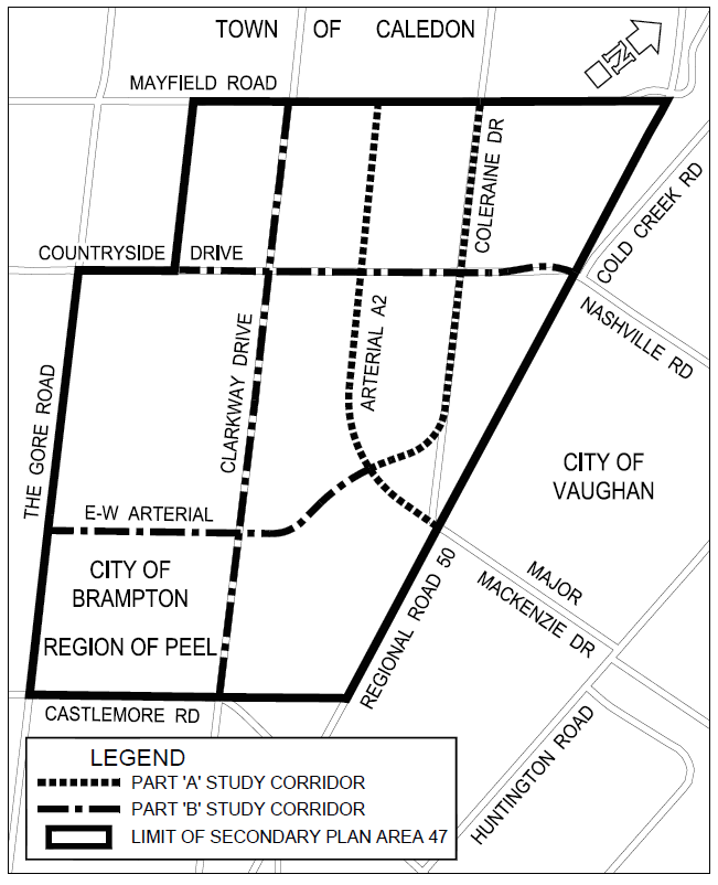
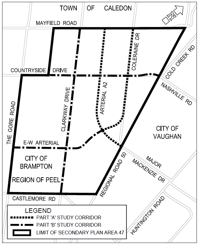
Arterial roads within Highway 427 industrial secondary plan area (Area 47)
The City of Brampton (City), in partnership with the Peel Region (Region), has completed two Schedule ‘C’ Municipal Class Environmental Assessment (Class EA) studies for the following roads:
Part A
- North-South Arterial (A2), a new north-south arterial roadway from Mayfield Road to Major Mackenzie Drive/Regional Road 50.
- Coleraine Drive from Mayfield Road to Arterial A2.
Part B
- East-West (E-W) Arterial, a new east-west minor arterial roadway from The Gore Road to Arterial A2.
- Clarkway Drive from Castlemore Road to Mayfield Road.
- Countryside Drive from west of Clarkway Drive to Regional Road 50 including possible realignment at Regional Road 50.
Details of the Class EA Study can be accessed on this webpage. The Class EA Study has been completed and the project has moved into the next phase ‘Detailed Design & Construction’.
For questions or inquiries, please contact:
Scott Durdle,
Project Manager
Design and Construction, Transportation
- Notice of EA Addendum
- EA Addendum Study Report
- EA Addendum Study Report Stakeholder Correspondence and Comments
- EA Addendum Study Report Engineering Plans
- Environmental Study Report - Part A
- Appendix A – Public Consultation
- Appendix B – Indigenous Consultation
- Appendix C – Agency Consultation
- Appendix D-1 – Traffic Analysis Report
- Appendix D-2 - Access Management Report
- Appendix D-3 - Safety Review of Existing Conditions
- Appendix D-4 - Vision Zero Assessment
- Appendix E - Natural Environment Assessment
- Appendix F - Vegetation and Aesthetic Assessment
- Appendix G1 - Stage 1 Archaeological Assessment
- Appendix G2 - Additional Stage 1 Archaeological Assessment
- Appendix G3 - MTCS Letter
- Appendix H - Cultural Heritage Assessment Report
- Appendix I - Contamination Overview Study
- Appendix J - Stormwater Drainage Assessment
- Appendix K - Fluvial Geomorphology
- Appendix L - Geotechnical Investigation
- Appendix M - Hydrogeological Assessment
- Appendix N - Road Traffic Noise Impact Study
- Appendix O1 - Structural Assessment - Arterial A2-S1
- Appendix O2 - Structural Assessment - Coleraine-S1-S1
- Appendix O3 - Structural Assessment - Hwy 50-S1-S1
- Appendix P1 - Arterial A2 - Plan & Profile
- Appendix P2 - Arterial A2 - Typical Section
- Appendix P3 - Coleraine Drive - Plan & Profile
- Appendix P4 - Coleraine Drive - Typical Section
- Appendix P5 - Highway 50_Arterial A2_Major Mackenzie intersection - Interim
- Appendix P6 - Highway 50_Arterial A2_Major Mackenzie intersection – Ultimate
- Appendix Q - Detailed Cost Estimate
- Appendix R - Streetlighting Design - Proposed Street Lighting
- Environmental Study Report – Part B
- Appendix A – Public Consultation
- Appendix B – Indigenous Consultation
- Appendix C – Agency Consultation
- Appendix D1 – Traffic Analysis Report
- Appendix D2 – Safety Review of Existing Conditions
- Appendix D3 – Vision Zero Assessment
- Appendix E – Natural Environment Assessment
- Appendix F – Vegetation and Aesthetic Assessment
- Appendix G1 – Stage 1 Archaeological Assessment
- Appendix G2 – Additional Stage 1 Archaeological Assessment
- Appendix G3 – MTCS Letter
- Appendix H – Cultural Heritage Assessment Report
- Appendix I – Contamination Overview Study
- Appendix J – Stormwater Drainage Assessment
- Appendix K – Fluvial Geomorphology
- Appendix L – Geotechnical Investigation
- Appendix M – Hydrogeological Assessment
- Appendix N1 – Road Traffic Noise Impact Study-compressed – Body
- Appendix N2 – Road Traffic Noise Impact Study-compressed – Appendix A-C
- Appendix N3 – Road Traffic Noise Impact Study-compressed – Appendix D
- Appendix N4 – Road Traffic Noise Impact Study-compressed – Appendix E
- Appendix N5 – Road Traffic Noise Impact Study-compressed – Appendix F
- Appendix N6 – Road Traffic Noise Impact Study-compressed – Appendix G-H
- Appendix O – Structural Assessment Report
- Appendix P1 – Clarkway Drive
- Appendix P2 – Countryside Drive
- Appendix P3 – EW Arterial
- Appendix Q – Detailed Cost Estimate
- Appendix R – Streetlighting Design
- Appendix R1 – Streetlighting Design
- Appendix R2 – Streetlighting Design
- Appendix S – Utility Report
- Appendix T – Air Quality Assessment Report
- Clarkway Drive Roll Plan
- Countryside Drive Roll Plan
- EW Arterial Roll Plan
The Class EA Study for Part A was completed in fall 2022. Recommended improvements under Part A include:
- New north-south 6-lane arterial roadway with multi-use paths on both sides from Major Mackenzie Drive/Regional Road 50 to Mayfield Road, including at-grade intersection with Regional Road 50 until traffic operations indicate the need for a grade separation, and
- Widening of Coleraine Drive from 2 to 4 lanes with multi-use paths on both sides from Arterial A2 to Mayfield Road, including realignment of Coleraine Drive to connect with Arterial A2 west of Regional Road 50.
The Class EA Study for Part B has been completed. Recommended improvements under Part B include:
- New east-west 4-lane arterial roadway between The Gore Road and Arterial A2 to provide connectivity for future development lands between Countryside Drive and Castlemore Road.
- Widening of Countryside Drive to the south from west of Clarkway Drive to Regional Road 50 to limit impacts on existing residential property.
- A realignment of the intersection at Countryside Drive and Regional Road 50 to improve turning visibility for drivers.
- Widening of Clarkway Drive evenly about the existing centre line from Castlemore Road to Mayfield Road. Further detailed assessment of any potential impacts to Clarkway Creek will be completed during the design stage for Clarkway Drive.
In addition, a request may be made to the Ministry of Environment, Conservation and Parks for an order requiring a higher level of study (i.e., requiring an individual/comprehensive EA approval before being able to proceed), or that conditions be imposed (i.e., requiring further studies) on the grounds that the requested order may prevent, mitigate or remedy adverse impacts on constitutionally protected Aboriginal and treaty rights. Requests on other grounds will not be considered.
Requests should specify what kind of order is being requested (request for additional conditions or a request for an individual/comprehensive environmental assessment), how an order may prevent, mitigate or remedy potential adverse impacts on Aboriginal or Treaty rights, and any information in support of the statements in the request. Requests should also include the requester contact information. This will ensure that the Ministry is able to efficiently begin reviewing the request.
Requests should be sent by February 24, 2023, in writing or by email to:
Minister of the Environment, Conservation and Parks
777 Bay Street, 5th Floor, Toronto, ON M7A 2J3
minister.mecp@ontario.ca
And,
Director, Environmental Assessment Branch
Ministry of the Environment, Conservation and Parks
135 St. Clair Avenue West, 1st Floor, Toronto, ON M4V 1P5
EABDirector@ontario.ca
Requests should also be copied to the project team members at the City of Brampton and Region of Peel by mail or e-mail.
Please visit the Ministry’s website for more information on requests for orders under section 16 of the Environmental Assessment Act.
All personal information included in your request – such as name, address, telephone number and property location – is collected, under the authority of section 30 of the Environmental Assessment Act and is collected and maintained for the purpose of creating a record that is available to the general public. As this information is collected for the purpose of a public record, the protection of personal information provided in the Freedom of Information and Protection of Privacy Act (FIPPA) does not apply (s.37). Personal information you submit will become part of a public record that is available to the general public unless you request that your personal information remain confidential.
- City of Brampton project website
- Notice of Public Information Centre #2 - November 14, 2019