Derry Road East and Alstep Drive road improvements
Notice of study completion
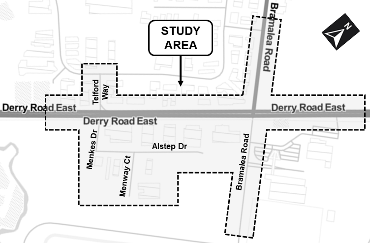
July 14, 2022 - Bombardier Inc., in partnership with the City of Mississauga and the Region of Peel (The Proponents), has completed a Municipal Class Environmental Assessment (Class EA) Study to assess existing and future road conditions on Derry Road East and Alstep Drive near Menkes Drive and Bramalea Road. The Study includes Derry Road East (a Regional Road) as well as Bramalea Road, Menkes Drive, Telford Way, Alstep Drive and Menway Court (all City roads).
The Study was conducted as a “Schedule C” project under the Municipal Class Environmental Assessment (October 2000, amended 2015), which is approved under the Ontario Environmental Assessment Act.
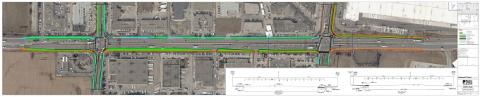
The planned improvements will benefit all transportation modes including pedestrians, cyclists, transit users and motorists. Recommended improvements within the study area include:
- Extension of Alstep Drive, easterly to Bramalea Road, with a three-lane cross-section;
- Widen paved surfaces along Menkes Drive / Telford Way, Bramalea Road and Derry Road East to accommodate road and intersection improvements; and,
- Improvements to the active transportation network,including additional sidewalks and upgraded/new multi-use paths within the study area.
Report documents
- Environmental Study Report
- Appendix A - Class EA Process
- Appendix B - Stakeholder, Agency and Public Consultation
- Appendix C - Transportation Assessment Report
- Appendix D - Stage 1 Archaeological Assessment
- Appendix E - Cultural Heritage Resource Assessment
- Appendix F - Background Hydrogeological Assessment
- Appendix G - Phase 1 Environmental Site Assessment
- Appendix H - Natural Environment Report
- Appendix I - Geotechnical Investigation and Pavement Analysis
- Appendix J - Drainage and Stormwater Management Report
- Appendix K - Evaluation of Alternative Solutions
- Appendix L - Alternative Designs Report
- Appendix M - Property Impacts Report
- Appendix N - Utility Impacts Report
- Appendix O - Tree Preservation Report
- Appendix P - 30% Design Drawings
- Appendix Q - Preferred Alternative Designs
Contact
If you have questions or wish to be added to the project mailing list, please e-mail derryroadea@exp.com or contact one of the team members.
Yves Marie Monereau, P.Eng., PTOE, RSP
Consultant Project Manager, EXP Services
Tel: 905-793-9800 Ext. 2336
Syeda Banuri, M.Eng., P.Eng.
Program Manager, Region of Peel
Tel: 416-407-7860
Ryan Au, P.Eng.
Project Manager, City of Mississauga
Tel: 905-615-3200 Ext. 3713
A virtual PIC was held on Monday, February 28, 2022. The PIC covered a presentation by the project team describing the project and the study’s preliminary preferred alternative designs. Comments are invited to be submitted by March 14, 2022. Accessible material is available upon request.
PIC documents
Alternative designs
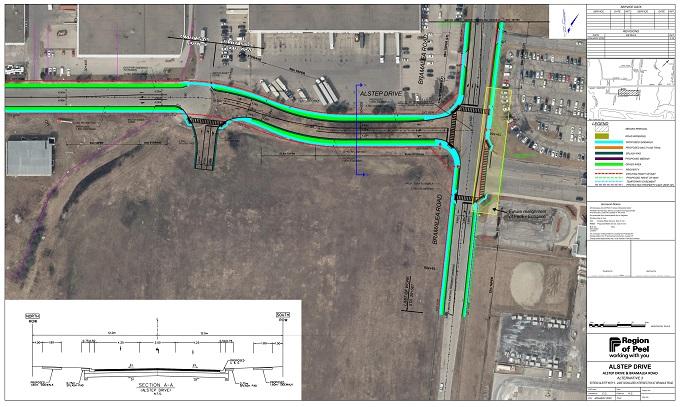
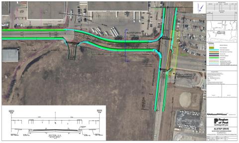
Alstep Drive extension
The preferred alternative solution included the extension of the existing Alstep Drive through to Bramalea Road. The recommended alternative design for the Alstep Drive extension and its intersection with Bramalea Road include:
- Extension of Alstep Drive to include a 3-lane signalized intersection at Bramalea Road; and
- Sidewalks with boulevard on the north and south sides of the Alstep Drive extension.
The extension would also include moving the FedEx Entrance to be aligned with the intersection.
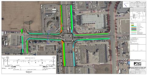
Intersection of Derry Road East and Menkes Drive/Telford Way
The preferred alternative solution included geometric and operational improvements at the intersection of Derry Road East with Menkes Drive / Telford Way. The recommended alternative design improvements at this intersection includes:
- Adding a second northbound left-turn lane on Menkes Drive.
- Retrofitting of the existing traffic islands to smart channels.
- Widening of Menkes Drive on both sides of the road, where necessary to accommodate the additional turning lane and road realignments.
- New sidewalks on the east side of Telford Way, the north side of Derry Road East (west of Telford Way), and the west side of Menkes Drive.
- Upgraded multi-use path on the south side of Derry Road East as they near Menkes Drive.
- Sidewalk improvements on the north side of Derry Road East, on the east side of Telford Way.

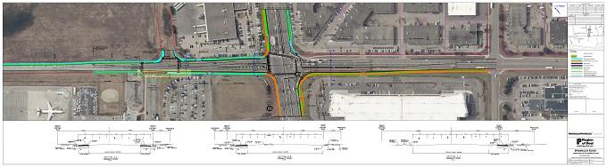
Intersection of Derry Road East and Bramalea Road
The preferred alternative solution included geometric and operational improvements at the intersection of Derry Road East with Bramalea Road. The recommended alternative design improvements at this intersection includes:
- Adding new turning lanes and/or the separation of combined through and turn lanes:
- New dedicated left turn lane on Bramalea Road southbound.
- Conversion of existing through/left turn lane on Bramalea Road southbound to a dedicated through lane.
- New left turn lanes on Derry Road East, both westbound and eastbound.
- Separation of through and right turn lanes on Bramalea Road northbound, south of Derry Road East.
- Retrofitting existing traffic islands to smart channels.
- Addition of near-side partial queue jump lane for buses travelling westbound (north side (Derry Road East, east of Bramalea Road).
- Minor road widenings on Bramalea Road and the north side of Derry Road East to accommodate additional turning lanes and improvements.
- Improvements to Active Transportation infrastructure:
- New sidewalks on both sides of Bramalea Road (south of Derry Road East).
- New multi-use path on the east side of Bramalea Road (north of Derry Road East).
- New sidewalk on the north side of Derry Road East (west of Bramalea Road).
Active Transportation Improvements
Improvements to the active transportation infrastructure in the study area were also incorporated into the recommended alternative design. These active transportation improvements include:
- Adding a sidewalk on the north side of Derry Road from Bramalea Road to the western limits of the study area.
- Upgrading the multi-use path on the south side of Derry Road (west of Bramalea Road) to include a 3-metre-wide path with boulevard separating it from the Derry Road East.
- Adding a multi-use path on the north side of Derry Road, east of Bramalea Road.
- Adding sidewalk to the south side of Alstep Drive and on the west side of Menway Court.

Bombardier Inc., in partnership with the City of Mississauga and the Region of Peel, has initiated a Municipal Class Environmental Assessment (Class EA) study to assess existing and future road conditions on Derry Road East and Alstep Drive near Menkes Drive and Bramalea Road. The study includes Derry Road East (a Regional Road) as well as Bramalea Road, Menkes Drive, Telford Way, Alstep Drive and Menway Court (all City roads).
The Class EA study has examined how traffic operates on these roadways now and in the future and will identify how best to manage issues related to roadway safety and traffic operations as well as service a variety of users such as motorists, transit users, pedestrians and cyclists.
The study is being conducted as a “Schedule C” project under the Municipal Class Environmental Assessment (October 2000, amended 2015), which is approved under the Ontario Environmental Assessment Act. Through this Class EA process, the Project Team is evaluating alternative solutions and designs to select a recommended design, all in consultation with the public and regulatory agencies. An Environmental Study Report (ESR) documenting the entire study process will be available for public review at the end of the study.
The Class EA Study is currently in Phase 3, which includes the identification and evaluation of Alternative Designs for the Preferred Solution.
In Phase 2, alternative solutions were identified and evaluated and made available to the public and stakeholders for review and comment at the Virtual Public Information Centre #1.
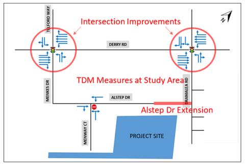
PIC #1 provided a detailed review of the Alternative solutions and their evaluation. In summary, the recommended solution for this Class EA is as follows:
- The improvement of operations at the intersections of Derry Road East with Menkes Drive and Bramalea Road, including geometric and operational improvements. The alternative designs for these local improvements will be identified and evaluated in Phase 3 and will be reviewed in Virtual PIC #2.
- Application of Transportation Demand Management (TDM) measures to help the redistribution of demand and reduce the overall traffic capacity peaks. Implementation of TDM in the Phase 3 Alternative Designs considered transit infrastructure plans for the area.
- The extension of Alstep Drive eastward to Bramalea Road. This will provide an additional route option for commuters to fulfill the City’s original intent for the area as depicted by the existing road allowance. Alternative designs for the extension will be undertaken in Phase 3 and will be reviewed in Virtual PIC #2.

PIC #1 was held virtually for this project in July 2020. Information from PIC #1 continues to be available for review: